All Articles
Jerritt Canyon Mill May Reopen
February 2009 by Scott Harn
Golden Eagle stated in a release that they were unable to announce the agreement until mid-January because certain conditions of the agreement had to be met first.Silver Peak, Nevada: A Little of Everything
 Silver Peak is a small mining community in Esmeralda County in west-central Nevada, about 30 miles west of Goldfield. Although it’s fairly remote, it’s been an important mining center since the early days.
A Break in the Weather
Back at the entry point of the mine, we took turns slowly crawling down the slope leading into the mine portal with our metal detectors, hard hats and flashlights. The mine was hand dug and is about 75 yards long.
Pullin' the Pin
I first saw Pioche, Nevada while hitch-hiking into town in an old Ford with three good tires and one wheel hammered to an ugly steel disc on fifty miles of blacktop.
The Bawl Mill
• Unicorns, fairies and cellulosic biofuel
• Who wants to be a millionaire?
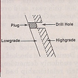
Small Mine Selective Blasting
 Drill holes in a mineralized vein often penetrate hidden layers of poor ore which, after blasting, end up diluting the production quality. Disseminated gold ores carrying two ounces per ton may be identical in appearance to adjacent vein material...
The Bawl Mill
• Cash for Carts
• No photos please...
• We couldn’t have said it better ourselves
• Mother Nature to the rescue...
Mining Stock Quotes and Mineral & Metal Prices
Subscription Required:
The Bawl Mill
• Our Readers Say
• Oldest Journal Contest - The Winners
• The St. Louis Gold District
• Mining Boom May Be In Store For Upper Michigan
• Mining Gold Near Elk Creek, Oregon
• East Coast Dredger Heads West - Part II
• Lost Canyon
• High Court to Rule on Kensington Tailings
• Prospecting in Tennessee
• A Warning About Mercury
• NovaGold Resources Receives Lifeline
• Looking Back
• Melman on Gold & Silver
• Mining Stock Quotes, Mineral & Metal Prices


