All Articles
Gold & The Dollar
July 2002 by Rep. Ron Paul
 Following is a speech Rep. Ron Paul delivered to the House of Representatives in early June, making a case for the return to the gold standard.—Editor
The Ferris-Haggarty Copper-Gold Mine, Grand Encampment District, Wyoming
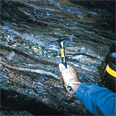 At the close of the 19th Century, optimism was high that Wyoming would become an important source for copper much like the neighbor states of Colorado, Utah, and Montana. This dream was short-lived...
Ask The Experts
• Reason for adits rather than shafts?
Striking Gold
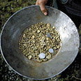 There’s a lot of luck involved when it comes to finding gold. Sometimes it’s being in the right place at the right time. Other times it’s simply by accident that discoveries are made.
Back to Basics--Finding Gold With a Pan and a Sluice
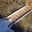 Don’t hunker down and just keep digging in one spot where there is very little or no gold—if you don’t find it, you’ve got to get up and move on!
Mining Stock Quotes & Mineral and Metal Prices
Executive Defends Special Mill Site Exemption
Hardrock mining never would have happened in the United States if a recent interpretation of the nation's mining law had been in effect in the 1890s, a mining executive says.
Melman on Gold & Silver
Strange, isn’t it, how our vocabulary has been expanding of late. Up until late 2001, the term “Twin Towers” meant either the combination of the Federal Budgetary Deficit and the National Debt or the two outstanding forwards of the NBA’s San Antonio Spurs. Suddenly, the only relevant meaning was the two destroyed buildings in New York City. By mid-2002, most of us who hadn’t given Afghanistan a second thought became familiar with names of towns and regions in that country.
Subscription Required:
The Bawl Mill
• Our Readers Say
• Siskiyou National Forest Update
• Company Looks at Restarting Sunshine Mine
• Piedmont Gold
• Picks & Pans: Exploring Wyoming's High Desert
• Sons of Gwalia & Herbert Hoover
• Looking Back
• Prospecting on the Yukon River
• Placer Gold in Arizona
• The Fire Assay of Fly Eyes
• Bill Could Create New Silver Market
• 2002 Inductees to the National Mining Hall of Fame
• Mining Stock Quotes and Mineral & Metal Prices
• Melman on Gold & Silver
• Mystery of Olmec Jade Solved