All Articles
Utilizing Geologic Maps
April 2006 by Lawrence Dee
Geologic maps generally appear complex and daunting, and certainly some are. However, many have information hidden within their bright splashes of colors and patterns that can aid the prospector who takes the time to study them.Oregon Miners Still Fighting
On October 19, 2015, the Waldo and Galice Mining Districts (of SW Oregon), along with several Oregon mining organizations and individuals, filed a Complaint in the United States District Court in Medford…
A Warning About Mercury
I was working on an article to submit to you and had been for a couple of months. It won’t be the first. I had something occur that made me put off the article—safety! My article was concerning mineral processing at home.
Melman on Gold & Silver
...one of our most important technical indicators, the “Dow/Gold Ratio,” may be giving off an important signal at this time, which we discuss briefly...
Fountain of Youth Gold
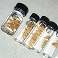 Across and downstream of our operation was a large pile of huge boulders. It was logical to think that water forces may have deposited gold in and around these boulders. We moved our dredge over and started pulling the rock pile apart.
The Bawl Mill
• Even Navy Seals aren't safe from hackers
• Good news, bad news
Company Notes
• U.S. Gold Corporation
• AZCO Mining Co.
• Canyon Resources Corporation
• Placer Dome, Inc.
• Vista Gold Corp.
• Grupo Mexico
Industry Urges Restraint on Mining Reforms
Wyoming mining interests say the federal government doesn't need tougher environmental cleanup rules governing mineral extraction from public lands.
Subscription Required:
The Bawl Mill
• Federal Court to Address Dredge Permits—The Tulloch Rule
• Basic Geology for the Independent Miner—Part IV Geology of Hardrock Gold Deposits
• Economic Impact of Mining in Alaska
• The Kenai Peninsula Goldfields
• Copper Price Keeps Canadian Miners Busy
• The Business of Mining: Financial Recoveries for Mandated Changes
• The Rich Hill Outing
• Picks & Pans: Detecting at Ganes Creek
• Copper Mine Opening in Utah
• Future of Mining in Bolivia Uncertain
• Melman on Gold & Silver
• Mining Stock Quotes and Mineral & Metal Prices