All Articles
Future of Mining in Bolivia Uncertain
April 2006 by Associated Press
The miners offer the still-beating hearts of four freshly-sacrificed llamas to a statue of the fiendish god “El Tio,” who they believe affords them protection and good luck.Additional articles that might interest you...
Dredging the Mokelumne
February 2008
 Gold mining adventures can begin in the most unusual fashion. This one started when the high water receding in May of 1999 disclosed that a tragedy had occurred somewhere upstream of Slaughterhouse Gulch on the north fork of the...
Gold mining adventures can begin in the most unusual fashion. This one started when the high water receding in May of 1999 disclosed that a tragedy had occurred somewhere upstream of Slaughterhouse Gulch on the north fork of the...
Legislative and Regulatory Update
July 2008
• Latest assault on dredging in California
• Travel Management Plans
• Latest assault on dredging in California
• Travel Management Plans
In Pursuit of Gold and Silver in the Sierra Madres—Purchasing Land in Mexico
March 2007
My wife and I spent three years laying the groundwork to build a processing mill for gold, silver, lead and some zinc in the Sierra Madre Mountains of Northern Mexico, in the state of Sonora. In this installment, I describe how we purchased the land to build the new mill.
My wife and I spent three years laying the groundwork to build a processing mill for gold, silver, lead and some zinc in the Sierra Madre Mountains of Northern Mexico, in the state of Sonora. In this installment, I describe how we purchased the land to build the new mill.
The Bawl Mill
June 2011
• California puts the “to go” in Carl’s Jr. business and others...
• Do you think Congress is serious about cutting spending?
• IMF chief needs his own bailout
• California puts the “to go” in Carl’s Jr. business and others...
• Do you think Congress is serious about cutting spending?
• IMF chief needs his own bailout
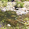
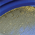
What To Look For—And Look Out For—In A Placer Mineral Report
May 2015
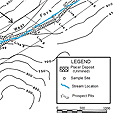 Buying a placer claim or investing in a placer mining property comes with plenty of financial risks. You need as much information as possible about the mineral deposit in order to minimize those risks.
Buying a placer claim or investing in a placer mining property comes with plenty of financial risks. You need as much information as possible about the mineral deposit in order to minimize those risks.
Gold Prospecting & Mining Summit Exceeds Expectations
May 2014
 Brian...had cleared off some virgin, gold-bearing bedrock areas prior to our arrival, so everyone had ample opportunity to find and take home some gold.
Brian...had cleared off some virgin, gold-bearing bedrock areas prior to our arrival, so everyone had ample opportunity to find and take home some gold.
Using Geologic Maps
December 2015
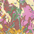 In order to see what geologic maps can do, we need to think about what we are looking for.
In order to see what geologic maps can do, we need to think about what we are looking for.
Subscription Required:
The Bawl Mill
• Federal Court to Address Dredge Permits—The Tulloch Rule
• Basic Geology for the Independent Miner—Part IV Geology of Hardrock Gold Deposits
• Economic Impact of Mining in Alaska
• The Kenai Peninsula Goldfields
• Copper Price Keeps Canadian Miners Busy
• The Business of Mining: Financial Recoveries for Mandated Changes
• Utilizing Geologic Maps
• The Rich Hill Outing
• Picks & Pans: Detecting at Ganes Creek
• Copper Mine Opening in Utah
• Melman on Gold & Silver
• Mining Stock Quotes and Mineral & Metal Prices