All Articles
The Fortymile Goldfields
March 2006 by Ron Wendt
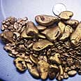 Having made nearly forty trips into this region over the years, the area has a tendency to draw the individual into its unique winding roads, which were once mining trails, where the creeks and rivers run to and fro across its twisted topography.
Additional articles that might interest you...
Melman on Gold & Silver
July 2011
Perhaps the most important phase of our chart analysis work is to find indicators that have proven reliable in the past in terms of providing indications of future market direction. One of our favorites is the “Bank Index,” better known by its trading symbol, BKX.
Perhaps the most important phase of our chart analysis work is to find indicators that have proven reliable in the past in terms of providing indications of future market direction. One of our favorites is the “Bank Index,” better known by its trading symbol, BKX.
Legislative and Regulatory Update
August 2018
• Pruitt out at EPA
• NDAA still under negotiation
• AMRA’s California mining bill fails to reach floor vote
Ask The Experts
April 2016
• Should I focus efforts on this particular rock type?
• Should I focus efforts on this particular rock type?
Melman on Gold & Silver
October 2002
The world remains a fascinating place to watch, for it seems that just when some of the most serious problems appear to be on their way to resolution, a whole new collection crops up. We appear to have been in just that type of environment this past month.
The world remains a fascinating place to watch, for it seems that just when some of the most serious problems appear to be on their way to resolution, a whole new collection crops up. We appear to have been in just that type of environment this past month.
The Last Chance Mining District
August 2009
 With all of the erosion patterns wearing away the channels down into the North Fork of the Middle Fork, we assumed placer gold was still available in the river. The question became: How do we get down the 1,600-foot elevation drop to reach the river?
With all of the erosion patterns wearing away the channels down into the North Fork of the Middle Fork, we assumed placer gold was still available in the river. The question became: How do we get down the 1,600-foot elevation drop to reach the river?
Subscription Required:
The Bawl Mill
• A Word from the Editor
• Basic Geology for the Independent Miner—Part III Understanding Plate Tectonics, Volcanism and Mountain Building
• The Rocks that Burn—Part II Is Oil Shale the Answer?
• Record Interest at Recent Mining Conventions
• Common Operations—Small-Scale Mining and Sharing the "Take"
• Trout Thriving In Treated Mine Water
• Company Notes
• Melman on Gold & Silver
• Mining Stock Quotes and Mineral & Metal Prices