All Articles
Border Silver
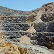
January 2003 by Edgar B. Heylmun, PhD
There is a sizable area that straddles the U.S.-Mexico border where native silver occurs in shear zones at relatively shallow depths. The district is in the low but rugged Pajarito Mountains, the highest point of which is 5,838 feet at Cerro Ruido, on the Mexican side. The deceptively rough terrain forced the first border surveyors, in 1855, to kill several mules and horses because of their injuries.Gold and Mining Stocks Will Rebound—But When?
 There is no question the economy will not always be as good as it is now. There is also no doubt that someday the lack of exploration and the ore in existing mines running out will come home to roost.
Ask The Experts: Looking for help on unproven claim
Looking for help on unproven claim
Update: Forest Service Interim Rule
On July 9, 2004, Under Secretary of the Department of Agriculture, Mark Rey, published the “Interim Rule.” By its own terms, the Interim Rule became effective on August 9, 2004, without regard to public comments. Public comments were, however, received until September 7, 2004.
Legislative and Regulatory Update
• Idaho EPA may pare back agressive water stance
• House panel recommends changing federal mineral royalty
• Gold mining company raises funds to fight initiative
• Comment period extended
Miner Wins Important Victory Against Forest Service
 A case involving a Northern California dredger who was cited by the Forest Service for operating without a Notice of Intent, Plan of Operation or special-use authorization was resolved in the miner’s favor.
Company Notes
• Pan American Silver Corp.
• ESG Canada
• Vista Gold Corp.
The Bawl Mill
• Energy conservation? Or investing in power?
• Collecting Dividends from the "Brown" fund
• Come rain, sleet, or snow...
Subscription Required:
The Bawl Mill
• The Old Dutch Cleanser Mine
• The Ferris-Haggarty Copper-Gold Mine, Grand Encampment District, Wyoming
• Directory of Active Mines in Arizona Available
• Picks & Pans: Gold Prospecting on the East Fork River, Alaska
• Beryllium in Nevada
• Company Notes
• The Cemetery Rush
• Grandfather John's Notes
• ICMJ's 12th Annual Photo Contest Results
• Tiffany & Co. to Open Plant in Northern Canada
• The Patio
• Looking Back
• Melman on Gold & Silver
• Mining Stock Quotes and Mineral & Metal Prices