History & Geology
WSGS Releases New Geologic Maps
December 2011 by Scott Harn
The Wyoming State Geological Survey announced ten new geologic maps have been completed and are now available.SS Central America Gives Up Millions in Gold Rush Era Gold
 A treasure-seeking young man whose name will forever remain anonymous made the months-long journey either over land or by sailing ship to California after word spread about the gold strike in 1849.
Critical Metals: Antimony
 I’ve been taking a look at the mining and uses of a number of critical metals in series of articles, and it’s time to take a look at antimony.
Green Valley Gold District, Payson, Arizona
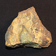
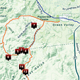 Most gold-bearing quartz veins found in the district were fracture fillings in faults enclosed by crushed quartz zones along their margins. Since the host rocks were often extensively weathered, portions of the veins stood out as positive, resistant outcrops. The gold-bearing veins ranged from a few inches wide to the vein at the Gowan mine that was as much as 12 feet wide.
 Researching Mineralized Areas
There are a load of ways to do research, and I’m going to talk about how I do it—maybe you’ll get some ideas that will work for you, too.
All About Garnets
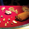
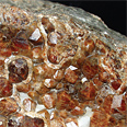 I get a lot of questions from prospectors about garnets, their value and what they tell us about the geology of some types of mineral deposits. So I thought it would be a good idea to take a closer look at the lowly garnet and learn a bit more about it.
Associated Gold Placers of the Comstock
 What many people don’t realize is that the Comstock Lode produced over 8,000,000 ounces of gold…
Gold Deposits of Montana
 Historically, Montana has been an important gold producer, in terms of both lodes and placers, and it still produces gold for the prospector today.
Subscription Required:
The Bawl Mill
• Our Readers Say
• Ask the Experts—Looking up mining claims on the Internet
• Ask the Experts—Access to mining claim across private land
• Ask the Experts—Best way to identify calaverite and sylvanite
• Legislative and Regulatory Update
• Prospecting on the North Yuba
• Yesterday's Gold—Today's Mine
• Where to Find Gold in Indiana
• Prospecting Australia—Part III Anatomy of a Nugget Patch in Western Australia
• Nevada Miners: Check Your Claim Markers
• Managers at Fault for Two Deaths at Meikle Mine
• Cold Water Gold
• River Dredging vs. Creek Dredging—Part I
• Melman on Gold & Silver
• Mining Stock Quotes and Mineral & Metal Prices
Free:
Ask the Experts—How do you determine how far a piece of gold has traveled in a stream?
• Testing Ores for Free Gold