Prospecting & Detecting
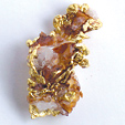
Where to Find Gold in Indiana
December 2011 by Chuck Lassiter
 You might think that gold prospecting techniques are basically the same everywhere, and in many instances you’d be correct. Some geographical locations, however, due to their unique geological conditions, present unusual challenges...
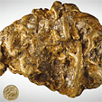
Detector Brings New Life to An Old Lode Mine
 …it was immediately evident the previous owner had not been using a detector. During just a few months of working the dumps part-time, he recovered gold in quartz specimens valued in excess of $40,000.
Maitland Bar Nugget to Go On Display
 The box sat in a hallway and employees began using it for impromptu cricket games, no knowing what it contained.
Revisiting an Old Mine in Idaho Reaps Rewards
 Our research indicated this whole area had been claimed by Newmont mining company for several years, but when the price of gold dropped they let the claims expire, and we confirmed this with the local BLM office.
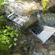
A New Prospecting Spot
 Once indicators start showing up along or below a contact I start to get excited. When I have shale, and outcroppings of diorite with iron-red, gritty soil and some clay thrown in, I really get lightheaded. I may be a mile away from the nearest diggings but that’s okay. I just found a spot that could provide some nice nugget hunting.
Getting Started
 He excitedly told me he was going mining and wanted to know where he should go, how to do it, and so on. After he calmed down, I got excited. “I need to go!” was my response.
Advantages of Modern Prospectors
Modern-day placer miners have many advantages over the prospectors of the gold rush days. Our prospectors can reap many benefits from accumulated knowledge of the last 100 to 150 years, which is a long and impressive list.
Mining Claims: Breaking All The Commandments
 So, I took the plunge. I decided on the maximum I would pay for the claim, then placed my bid. A day later I received a congratulations e-mail that I was the high bidder, and oh, by the way, send us your money.
Subscription Required:
The Bawl Mill
• Our Readers Say
• Ask the Experts—Looking up mining claims on the Internet
• Ask the Experts—Access to mining claim across private land
• Ask the Experts—Best way to identify calaverite and sylvanite
• Legislative and Regulatory Update
• WSGS Releases New Geologic Maps
• Prospecting on the North Yuba
• Yesterday's Gold—Today's Mine
• Prospecting Australia—Part III Anatomy of a Nugget Patch in Western Australia
• Nevada Miners: Check Your Claim Markers
• Managers at Fault for Two Deaths at Meikle Mine
• Cold Water Gold
• River Dredging vs. Creek Dredging—Part I
• Melman on Gold & Silver
• Mining Stock Quotes and Mineral & Metal Prices
Free:
Ask the Experts—How do you determine how far a piece of gold has traveled in a stream?
• Testing Ores for Free Gold