All Articles
Ask The Experts — How have fellow dredgers modified their dredges in order to retain fine gold?
March 2008 by David Knowlen
Q: In the article by David Knowlen, “There’s Still Gold in the Umpqua River,” January 2008, the author stated that “most conventional dredges with normal angles of sluice setup do not retain this gold.”...Silver Bull Resources Sees Bright Future for Silver & Zinc
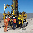 The Sierra Mojada Project lies within a historic high grade silver, lead and zinc mining district originally discovered in 1879.
Ask The Experts
How do I set up a Miller table?
The Bawl Mill
• Court to government: “Can you hear me now?”
• There’s gold in them thar… holes?
• FEMA (Free Easy Money for All)
A Break in the Weather
Back at the entry point of the mine, we took turns slowly crawling down the slope leading into the mine portal with our metal detectors, hard hats and flashlights. The mine was hand dug and is about 75 yards long.
Impact of Habitat Designations Grossly Underestimated
A UC Berkeley professor says the federal government is using an analysis method that seriously underestimates the economic impact of critical habitat designations for imperiled species.
Melman on Gold & Silver
After months of war news, rising unemployment, declining economic activity and heightened world tensions, the news background took a decided turn for the better last month—at least on the surface. The war in Iraq has died down to only an occasional moderate outburst. Tensions between Israel and its Palestinian neighbors appear to be on the decline. New unemployment claims have fallen and...
Proper Placer Sample Processing
...your sampling procedures should not be designed to catch gold your mining technique will never recover.
Subscription Required:
The Bawl Mill
• Ask The Experts — Could you please include the stock symbol in "Mining Stock Quotes"?
• Gryphon Gold and the Borealis Project
• A Modern Day Prospector’s Story
• Conducting Research To Find New Gold Deposits
• New Tax Considerations For Your Mining Business
• Searching for Gold at Paradise Valley, Alaska
• The Carson City Mint
• Melman on Gold & Silver
• Mining Stock Quotes and Mineral & Metal Prices