All Articles
The Tonopah Gold and Silver District
October 2009 by Chris Ralph
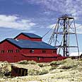 The discovery of the Tonopah District by Jim Butler in May, 1900, was by far the most important event of its time, just as the discovery of the Comstock was the most important event in the Nevada’s earlier history.
Additional articles that might interest you...
Looking Back
May 2002
Excerpts from California Mining Journal, our original title, published 50 years ago this month.
Excerpts from California Mining Journal, our original title, published 50 years ago this month.
The Price of Gold—Where It’s Headed and Why
November 2005
 For the past year, one of the most troubling questions raised at mining conventions and conferences has been, “Why have so many economic and social events occurred as predicted, but the precious metals remain locked in a...
For the past year, one of the most troubling questions raised at mining conventions and conferences has been, “Why have so many economic and social events occurred as predicted, but the precious metals remain locked in a...
Opening Ceremony for Buckhorn Mine
November 2008
“When the mine is in full operation, it will be the biggest private sector employer in Ferry County and bring significant economic benefits to the region..."
“When the mine is in full operation, it will be the biggest private sector employer in Ferry County and bring significant economic benefits to the region..."
China Ups Investment in Foreign Minerals
March 2005
Direct investment overseas by Chinese companies rose 27 percent over a year earlier to $3.6 billion in 2004, highlighting the country’s growing economic influence, the government reported.
Direct investment overseas by Chinese companies rose 27 percent over a year earlier to $3.6 billion in 2004, highlighting the country’s growing economic influence, the government reported.
Following Clues to a Hidden Gold Deposit
March 2012
 Many years ago I was in the American Canyon. I remembered a few details about a placer deposit there, so we decided to make a trip down and re-check some of these old workings.
Many years ago I was in the American Canyon. I remembered a few details about a placer deposit there, so we decided to make a trip down and re-check some of these old workings.
Ask The Experts
January 2016
Gold nuggets and serpentine contacts
Gold nuggets and serpentine contacts
A Practical Approach to Dowsing
June 2003
The use of dowsing methods to locate underground minerals and materials has been a rather delicate subject for some time. A certain stigma has been automatically attached to both the methods employed and the persons who use these techniques.
The use of dowsing methods to locate underground minerals and materials has been a rather delicate subject for some time. A certain stigma has been automatically attached to both the methods employed and the persons who use these techniques.
Subscription Required:
The Bawl Mill
• PLP Files Lawsuit to Lift Ban on Suction Dredging
• Legislative and Regulatory Update
• Bigger Is Not Always Better
• Gold in the Rattlesnake Hills
• Possible Discovery Sparks New Klondike Gold Rush
• Oregon Miner Challenges Forest Service’s Authority to Regulate Mining
• Dredging Alternative: High Banking
• The Fence
• California State Gold Panning Championships
• Mining Stock Quotes and Mineral & Metal Prices
Free:
Melman on Gold & Silver