History & Geology
Prospecting With The Help of Fluvial Geomorphology
March 2011 by Jim Halloran
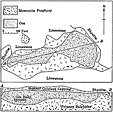
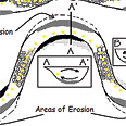 Quiz yourself about the stream in figure 5. Based on your previous knowledge of where gold is found in a stream and in this article, where do you think you will find the most gold?
The Rush to Treasure Hill
There were some exceptional times in the far-flung history of the West. Rich finds of minerals that set men’s souls ablaze. From the rich gold fields of California, men who arrived too late to find riches went searching in every direction. The trail that we will follow leads east, past the shining silver district of the Comstock Lode.
Prospecting for Surface Flood Gold Placers on Low and Intermediate Gradient Streams
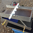 Sample panning is a very important method used to find the richest parts of a flood gold deposit before setting up equipment and running material.
Las Médulas—The Gem of the Roman Gold Mines
 This mine was a real wonder of engineering, and the water supply and drifts had to be carefully managed to keep it in operation. In fact, it didn’t close due to lack of gold, but instead closed with the fall of the Roman Empire.
The Paragenesis of Gold & Silver Deposits
 …if you are game for digging in and learning more about the intricate details of how gold deposits form, then let’s jump right in.
The Pedro Gold Dredge
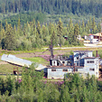 The decision was made to move the dredge intact, a massive undertaking indeed. The goal was to move it only one mile to the Busby’s Chicken Gold Camp, but what a mile that was to be.
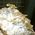
All About Pyrite
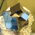 Most prospectors learn early that pyrite is fool's gold...but the truth is it can be an excellent indicator mineral for gold and in many cases does contain small amounts of gold.
The Ely Copper-Gold District of Nevada
 The main ore deposits of the Ely district are associated with an east-west belt of altered and mineralized rocks measuring about one mile wide that extends 8 miles westward from Ely.
Subscription Required:
The Bawl Mill
• So You Want To Be A Full-Time Prospector?
• Ask The Experts—Do I still have rights to this mining claim?
• Ask The Experts—What is a "closed" claim?
• Eastern Arizona: Gold and Base Metal Deposits Part II
• Rediscovering Placerville, California Part II
• Oregon Anti-Dredging Bill
• Mud Men: Pocket Miners of Southwest Oregon Part II
• The Gold of Plumas de Oro
• Melman on Gold & Silver
• Mining Stock Quotes and Mineral & Metal Prices
Free:
2011 Gold Prospecting & Mining Summit April 23-25 in Placerville
• Legislative and Regulatory Update
• Cue Resources Seeks Uranium in Paraguay