Prospecting & Detecting
Green Valley Reconnaissance
January 2013 by Don Robinson
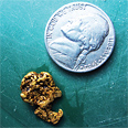 During this trip we found enough gold to make us want to come back, even with the punishment of a very long, tough hike.
A Trip Down the Yukon River
My girlfriend Beth and I decided to take our canoe down the Yukon and do some gold dredging...
It's Hard to Find Gold!
...even the best prospectors have times when they do not find gold. It is all about taking chances against tough odds and succeeding.
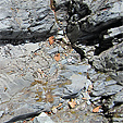
River Dredging vs. Creek Dredging—Part I
As I started walking down to the river one chilly morning, the mist was hanging over the calm portions of the water like a white cotton blanket. This scene got me to thinking about why the river was like that—the deep pools, boulder fields, gravel bars, the effects of how much water was moving at any given time along the watercourse—and most of all the relationship all these things have on where I will be able to find gold.
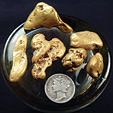
How Long Does It Take to Find and Recover An Ounce of Gold?
Some ask if a prospector can collect an entire ounce in a day. It is possible; I’ve done it before.
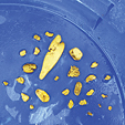
Sniping for Drought Gold
 There are not a lot of tools needed to get out and take advantage of the situation. Other than my wetsuit, I typically travel light with a gold pan, maybe a pry bar and a few crevice cleaning tools.
The Art of Underwater Nugget Shooting
 There is a surprising amount of detectable gold under the water’s surface. The right tools make it much easier to find, and with a little patience and practice you can take advantage of this underappreciated bonanza.
Keep Watch for The Unexpected
 As I have always done, I stashed those heavy black rocks in my pack and put them in the garden at home. They never were given a second thought until a half decade later…
Subscription Required:
The Bawl Mill
• From the Editor
• Ask the Experts
• Iron Minerals, Your Detector and Gold
• The Robinson Mine—Big Things Happen Here
• Forty-Six Nuggets
• Customizing Your Dredge
• Small Miner Beats Forest Service in Court
• Using Vegetation and Soil Conditions as Prospecting Aids
• Prospecting for Diamonds
• Gold Pour Signals Revival in the Mother Lode
• Melman on Gold & Silver
• Mining Stock Quotes and Mineral & Metal Prices