Prospecting & Detecting
Using Google Earth and Other Maps
November 2012 by Chris Ralph
Last month, one of our readers requested an article regarding the possible use of Google Earth for prospecting research. It was a good idea, so here it is.Prospecting and Mining Old Mine Sites
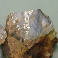 In some places valuable ores can be found within the waste material of mine dumps, sorted ore piles, and detrital vein matter at the surface. Though many of these old mine sites can be an excellent source of gold, not all are created equal.
Detecting Strategies for Heavily Forested Areas—Part II
 Patience and persistence is the name of the game when you are detecting this way for gold, as you will have to do a lot of work preparing the ground to detect with any degree of success.
Following the Clues
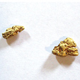
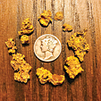 It took me awhile before I finally got a nice mellow signal. My nugget turned out to weigh in about two dwt (pennyweight). Over the next few hours, we all picked up a few more nuggets apiece.
Ask the Experts
Q: Will my detector react to fine gold?
Tips for Effective Drywashing
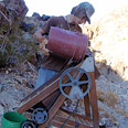 Back in October I read with great interest Chris Ralph’s article on the use of a metal detector while drywashing, and I wholeheartedly agree—I wouldn’t even consider going drywashing without using a metal detector in conjunction...
Searchers' Dreams
The story began in a southern Arizona mountain range...
Successful Rally for Suction Dredge Miners in Idaho
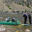 Representative Paul Shepherd stopped by, and Idaho County Commissioner Jim Chmelik dove with one of the dredgers so he could see for himself that no harm was being done to fish or their habitat.
Subscription Required:
The Bawl Mill
• Ask the Experts
• Ask the Experts
• Ask the Experts
• Ask the Experts
• The Portable XRF Gun
• Gold Dredging on Oregon's South Umpqua
• The Struggle to Reopen Alaska's Largest Gold Mine
• Prospecting With a Detector: Lessons Learned
• The Rush to Treasure Hill
• Tips on Crevicing for Gold
• Proper Assaying of Placer Samples
• Mining, Health Care & Taxes
• Melman on Gold & Silver
• Mining Stock Quotes and Mineral & Metal Prices