Prospecting & Detecting
Route Planning Using GPS
January 2019 by Peter Gleba
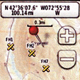 My intention was to end this discussion with waypoints and routes, then I found USGS maps of the Plainfield Quadrangle.
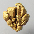
The Hunt for Remote Canyon Gold
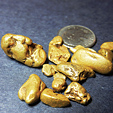 A large, 8-pennyweight piece popped out of a very small crevice where the water had been extremely swift in the winter, leaving no visible gravel.
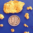
Quartzsite Gives Up Some Big Gold
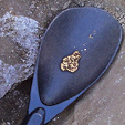 There is always an overwhelming feeling when finding gold of any size, but one like this doesn’t come along very often.
Bedrock
 I am going to break bedrock down a bit and explain my view of the varying scenarios I come across in the field.
Prospecting for Pegmatites
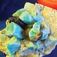 …in some cases pegmatites have produced individual mineral crystals that are enormous, attaining lengths of over 40 feet long, and many of the world’s largest mineral crystals are examples that were found within pegmatite deposits.
Who Jumped Whose Claim First?
 At this point, stress raised my blood pressure and I was figuring out escape routes through the brush, but thought it best to continue the conversation.
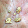
The Pothole Patch
 "Suh-wheet!" I exclaimed as I sprang to my feet and quickly pumped my detector coil high overhead to alert Smokey that I had just found a nugget.
Just Another Ordinary Weekend
 There was no evidence that anyone else had ever worked this gully with the exception of some old sample piles near the foot of the ravine.
Subscription Required:
The Bawl Mill
• Ask The Experts - Need advice on melting gold
• Ask The Experts - Can gold be found with sugary, crystalline quartz?
• Making A Big Discovery
• More On Gold Indicators—What to Look For
• The Underground Mining Adventure Continues
• Alaska Gold: Lisianski Inlet's First Bonanza
• Advancements in Non-Toxic Gold and Silver Leaching
• The Mineral Range Districts of Utah
• Gold Prospecting for Better or Worse: Stupid Is As Stupid Does
• Melman on Gold & Silver
• Mining Stock Quotes and Mineral & Metal Prices