All Articles
Free
Gold in Kansas and Oklahoma
January 2001 by Edgar B. Heylmun,
The Great Plains region, contrary to popular opinion, is not entirely flat. There are areas of low hills and badlands, and it is in such areas where gold has been found. The areas of interest range from 700 to 3,000 feet in elevation, with annual precipitation ranging from 15 to 40 inches, in the form of summer thunderstorms and winter snow. The region tends to be windy. Natural vegetation in the western half of the region consists of grasslands, with trees along creeks and rivers, ideal for cattle ranching. However, much of the land has now been cleared for wheat and other crops. All streamcourses ultimately drain into the Mississippi River.
History
After the war with Mexico, and with the Gold Rush to California in 1849, pioneers began to trek across the plains. Comanches and other Indians fiercely defended their territory, making things treacherous for miners and settlers. U.S. Army troops were stationed throughout the region to try to protect the wagon trains. When troops were pulled to fight in the Civil War, Indians went on a rampage and there were some bloody massacres. U.S. Cavalry units brought the Indians under control by 1875. Oklahoma was set aside as “Indian Territory,” but ranchers and miners entered the region anyhow. These were the “Sooners.” When Oklahoma was officially opened for settlement in 1889, many ranchers already had their lands staked.Gold
Kansas and Oklahoma are not known for gold, but there are scattered occurrences of gold in both states. Prospectors heading west to Colorado and California found placer gold in certain streamcourses. If they failed to find their fortune in Colorado or California, some of them returned to work areas they knew about in Kansas and Oklahoma. Unfortunately, there were mining men who were unscrupulous promoters who conducted scams, so it makes it difficult to separate fact from fiction in some areas. Geologists sent to investigate reports of gold were often convinced that there was no gold there even before they left their offices. So, there were cases of unbridled optimism vs. cases of undo pessimism. The truth probably lies somewhere in-between.Kansas
There have been reports of gold in Kansas for 150 years. The most publicized area is in west-central Kansas, near Hays and Russell. The potential gold-producing area is over 150 miles long (see map on page 16). Flour and micron gold have been found in flat-lying beds of the Carlile shale of Cretaceous age, in badlands along the drainage of the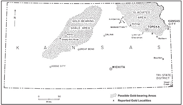 Smoky Hill River. It is a petroliferous dark gray to black shale, up to 300 feet thick, and when crushed to 100 mesh, considerable flour gold can be obtained. There have been promotional claims of 15 ounces gold/ton, but legitimate assays range from “nil” to 2.4 ounces gold/ton. In 1902, an entire carload of shale was sent to Dr. Ernest Fahrig in Philadelphia, and he found gold and silver in every run. The average tenor for the carload was 0.134 ounce gold and 2.6 ounces silver/ton.
The Carlile shale is soft and easily eroded, so it rarely crops out except in road cuts, along some streamcourses, and in badlands. Along the Smoky Hill River, it forms sizable areas of badlands, and it is in these badlands where most work has been done. The richest shales are pyritiferous and are oxidized at the surface to a brownish-yellow color. Because of the excitement, the U.S. Geological Survey sent the famed geologist, Waldemar Lindgren, to examine the area. Lindgren found that gold was too spotty to have commercial value, though he did note the presence of rich streaks. His work can be found in U.S. Geological Survey Bulletin 202, published in 1902.
In northeastern Kansas, finely-divided gold can be found in glacial drift. During the Ice Age, glaciers pushed as far south as northeastern Kansas. Where the ice remained at a standstill for a few hundred years, terminal or recessional moraines were formed. The drift and morainal material consist of gravels which were brought down from areas in Canada. Gold is irregularly dispersed in the glacial gravels, but where they have been reworked by running water, it may be possible to find workable placer deposits. Such localities have been noted at Wamego, Baldwin, and at many other places between Manhattan, Kansas, and Kansas City (see map).
In the Shoal Creek area in extreme southeastern Kansas, gold was reportedly found in yellowish-clay on bluffs on the south side of the creek. One assay supposedly contained 1.95 ounce gold/ton, and several shallow shafts were sunk. This is in the Tri-state lead-zinc district, but no gold has ever been found in the lead-zinc ores.
The Arkansas River, not shown on the map, flows through southwest and south-central Kansas. The source of the river is in rich gold districts in Colorado, and very finely divided gold can be found in bars and banks along the river. There is no feasible way to recover the gold.
Oklahoma
The best-known gold localities in Oklahoma are in the Wichita Mountains in the southwestern part of the state (see map). The low but rugged mountains extend northwest for 60 miles. In places, red granite knobs rise abruptly as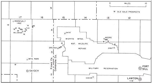 much as 1,000 feet above the surrounding plain. The granite and gabbro mountains are surrounded by a sea of flat-lying sedimentary rocks of Permian age. The main part of the mountains, covering 92 square miles, has now been set aside as a national wildlife refuge. The refuge is open for recreational use but is closed to mining. The Fort Sill Military Reservation to the east and south is closed to entry.
Spaniards entered the region as early as 1541, and there are the usual legends of lost Spanish mines. Prospectors found gold, and by 1890, a number of gold strikes had been made, and there was a gold rush. One strike near Lugert, west of the mapped area, supposedly encountered ore which assayed at over 150 ounces gold/ton. Ranchers and miners did not get along and there were occasional disputes and shootouts. By 1902, there were up to 2,000 prospectors in the mountains, many of whom had experience in Colorado. The U.S. Geological Survey studied the region and reported on the gold occurrences in Bulletin 225-B and Professional Paper 31, both published in 1904. In essence, they denounced the region as far as gold and silver were concerned, and ranchers took over in 1906 after all gold mines were closed.
There is no question there were unethical gold promotions, but gold exists and has been mined on a small scale. Quartz-calcite veins and stringers cut altered gabbro and diabase dikes. The most promising areas appear to be outside of the withdrawals, on privately-owned land. The three most important mining districts were as follows:
Meers. The hamlet of Meers still exists, but in 1902, there were 500 people living there. There were arrastres and reduction works for handling ore from 15 mines. At one mine south of Meers, specimens of leaf gold were found in association with quartz and calcite in a zone of contact metamorphism. The Shawnee Mining Company sank one shaft to a depth of 72 feet, and several carloads of ore were shipped.
Oreana. The Little Bar Mine was sunk east of Oreana on a diabase dike which cut granite. Ore was found at a depth of 35 feet and supposedly assayed as high as 2.5 ounces gold/ton, and ore shipped to Denver ran 0.62 ounce gold/ton. The Hale Copper Mine, in the same area, had some fine specimens of native copper. Some of their diggings can still be found.
Wildman. The Wildman Camp boomed between 1901 and 1904. The site was located in the Raggedy Hills southeast of Roosevelt, in T. 4 N., R. 17 W., Kiowa County. Wildman was one of the wildest places in the nation, with saloons, drunken fights, and shootouts. Ironically, a bloody battle was fought against Comanches at the same site 50 years earlier. There were 20 active mines during the boom. At the Tenderfoot Mine in section 18, T. 4 N., R. 16 W., values supposedly ran as high as 4.4 ounces gold/ton. At the nearby Last Drive Mine, values as high as 0.7 oz. gold/ton were found. The richest mines were on Nest Egg Mountain. At the Gold Bells Mine, a cyanide plant and reduction works were built, and several carloads of ore were shipped. On the Glen Mountain topographic quadrangle, published by the U.S. Geological Survey in 1956, a “Gold Mine” is shown in section 27, T. 4 N., R. 17 W., a mile southwest of the site of Wildman.
Diabase dikes cut gabbro which, in turn, are cut by quartz veins and stringers. Pyrite, chalcopyrite, and pyrrhotite can be found disseminated in altered gabbro. There have been sporadic attempts to mine gold in the area up until the 1950s. However, it should be noted that neither the U.S. Geological Survey nor the Oklahoma Geological Survey have been able to confirm the presence of gold anywhere in the Wichita Mountains. Based on the amount of past activity, the writer finds it hard to believe that no gold has ever been found.
Summary
Gold occurrences have been reported over sizable areas in Kansas and Oklahoma, and more work using modern methods might be in order. However, almost all land is privately-owned, so it would be necessary to obtain permission to enter from landowners. All signs and locked gates must be respected.Because of the finely-divided nature of gold found in the region, conventional methods of gold recovery might not be feasible. So, in that regard, the region is a challenge to prospectors.
Interested parties should check the aforementioned U.S.G.S. publications, as well as reports put out by the state geological surveys in Kansas and Oklahoma.
Late spring, summer, and fall are the best seasons for prospecting in the region. Food and lodging are available in Lawton (pop. 100,000) and Snyder (pop. 1,600).

© ICMJ's Prospecting and Mining Journal, CMJ Inc.