All Articles
Free
Where to Prospect for Gold in Colorado
December 2009 by Chris
Colorado is one of the more productive states when it comes to gold, ranking third, behind Nevada and California. The majority of the gold deposits are confined to a northeast-trending belt known as the Colorado Mineral Belt, located in the mountainous western part of the state. From a location near Boulder on the northeast, this belt extends south and west into the San Juan Mountains and beyond. This zone does not hold all of the mines. The Cripple Creek mining district, largest in Colorado, as well as several minor districts, lies in another zone southeast of the main mineral belt.
In the early 1800s, Colorado was explored by special expeditions, trappers and other pioneers, but apparently most of these early travelers paid little attention to the mineral deposits as they passed through. Even when the California discoveries brought new emigrants westward in search of gold, those pioneers did not seem to realize that gold was found in many places besides California. In Colorado, as it is in most places, placer gravels were the first form of mines worked, and by searching for their sources, many of the important vein deposits were discovered. Among the early California Argonauts was a band of Cherokees who stopped on their way to California and prospected some of the creeks and rivers of the Rockies eastern slope. They found a little gold in Ralston Creek, a tributary of the South Platte. It is said that Cherokee Indians occasionally brought small lots of placer gold from the upper Platte in the early 1850s, but the first major finds were not made until later in that decade.
In the spring of 1858, William Green Russell and his two brothers, placer miners originally from Georgia who had also dug for gold in California, led a party to prospect and explore along the South Platte River. They had heard of the find made by the Indians, and secured Cherokee guides to assist them in exploring the area. The group started out with about 100 prospectors.
They were not immediately successful in finding significant amounts of gold, and by the end of June, Russell found himself with only a dozen men remaining. He told them plainly that he had come across this country to prospect the Rocky Mountains and he was unwilling to give up. “If only one man will stay on with me,” he said, “I will continue until I am satisfied that no gold can be found, even if it takes all summer.”
They were on a constant lookout for favorable prospects. Occasionally they stopped and washed out a pan full of dirt to see if it would pay. One day, James H. Pierce was at the end of the wagon line, looking at the gravel bars along the creek bed, when he thought he saw some good looking gravel. He dug up a shovelful of sand and dirt and began washing it in his pan. Within a few moments William Russell came up to see the results. Along the bottom of the pan was a line of coarse gold flakes and small nuggets. Russell saw the gold and shouted, “‘Our fortune is made!”
The other men all jumped into the work with feverish haste, and in a short time they had mined a few hundred dollars worth of gold from the sands of the Platte. There were many rich and significant discoveries in Colorado in the following years. Miners spread out to explore the Front Range, and discovered rich placers at Empire, Georgetown, Idaho Springs, Breckinridge, Blackhawk and other diggings. Other prospectors moved up the Arkansas River and discovered rich gold deposits at California Gulch near what is now known as the Leadville district.
Front Range Geology
The area is underlain by continental igneous and metamorphic rocks, including contorted schists, interlayered gneiss, migmatite, and sheets, dikes and masses of granite and granodiorite. The veins generally fill north-northeast to east trending fractures and faults in Precambrian igneous and metamorphic rocks. These Precambrian rocks are intruded by a variety of Tertiary plutons and dikes. The mineralization ranges in age from late Cretaceous through late Tertiary. The veins generally run a few thousand feet in strike length, but do vary somewhat. They are mesothermal in origin, and thicknesses run from a few inches to nearly 40 feet. The most common ore minerals are base metal sulfides such as pyrite, chalcopyrite, galena, sphalerite and tennantite. They contain a variety of differing mineral assemblages, but are generally grouped into: 1) pyrite-quartz veins; 2) copper veins containing quartz, pyrite, chalcopyrite, tennantite, minor galena and sphalerite; (3) lead-zinc quartz veins containing quartz, pyrite, galena, sphalerite and subordinate chalcopyrite and tennantite, and (4) lead-zinc carbonate veins containing galena, sphalerite, and small amounts of chalcopyrite, tennantite and pyrite. All four types contain gold, but the most important mines are in the lead-zinc quartz veins. Gold occurs partly as discrete fine particles and is partly tied up in the sulfide minerals. A few gold telluride veins are found in the southeast part of the Central City district in Gilpin County. The gold is most commonly associated with pyrite and chalcopyrite, while silver is more closely associated with the tennantite.
Cripple Creek Geology
After Carlin and Homestake, Cripple Creek is the third most productive gold district in the US. The ores here have an origin much different from those of the Front Range. The gold deposits of the Cripple Creek district were formed within or at the margin of a Tertiary volcanic breccia mass. These rocks occupy a steep-walled volcanic caldera about 4 miles long and 2 miles wide that was formed by a series of gaseous explosions. Explosive fracturing and subsidence produced shear zones in the breccia and adjacent Precambrian rocks. Along these shear zones, various dikes and irregular masses of volcanic rocks were emplaced, including latite, syenite, phonolite, and lamprophyres. These dikes were more porous to fluids than the surrounding Precambrian granitic rocks, and in many places became the conduits for the ore bearing brines.
The ore deposits are epithermal in nature and occur in relatively short individual veins that are located along persistent vein zones. Many of these vein zones lie close to the margin of the breccia mass while others persist into the breccia or extend into the adjacent Precambrian rocks. The veins are narrow, high-grade zones mineralized with gold, silver and copper tellurides, pyrite, sphalerite, galena and tetrahedrite. The gangue minerals are chiefly quartz and fluorspar, with dolomite, ankerite and celestite.
The most spectacular discovery at Cripple Creek was the famed “Cresson Vug.” This opening was a cavity roughly 25 feet by 12 feet by 40 feet high. Discovered in November of 1914, the cavity was lined with gold tellurides, quartz, celestite and clay minerals. By the end of the year nearly 20,000 ounces of gold had been mined from this small area.
Colorado Placers
While most of the gold mined in Colorado came from lode mines, there were some significant placer producers. Six counties produced 50,000 ounces or more. These include Gilpin, which produced 50,000 ounces mostly from the Gregory Diggings and other placers areas around Blackhawk, Central City and Gamble Gulch in the Perigo mine area. Chaffee County yielded 90,000 ounces of placer, mostly from the Cache Creek area near Granite. Other placers were worked along the Arkansas, Lost Canyon Gulch, Chalk Creek, Cottonwood Creek, Pine Creek, Bertschey’s Gulch, Gold Run Gulch, Gilson Gulch, Oregon Gulch and Ritchey’s Patch.
Clear Creek County produced 140,000 ounces of placer, most of which are in Clear Creek or its tributaries, including Chicago Creek near Idaho Springs. Additional important placers were mined in Nevada and Illinois gulches and Missouri Flats.
Park County yielded 350,000 ounces of placer gold, mostly from deposits in the Fairplay, Tarryall, and the Alma districts. Tarryall Creek and the South Platte River have both been highly productive.
Lake County produced 360,000 ounces of placer gold, principally from Iowa and California Gulches, tributaries of the Arkansas River, in the Leadville district. Some gold also came from the Arkansas River valley.
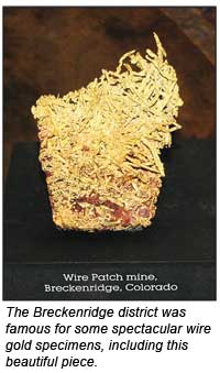
Summit County was the most productive county in Colorado for placers, producing over 750,000 ounces of gold. The Breckenridge district was the major producer here. Rich gold placers were discovered along Georgia Gulch on the north side of Farncomb Hill in 1859, and soon afterward placers were discovered along many other streams and gulches in the district. Farncomb Hill is famous for its rich deposits of native gold, which has supplied specimens of wire and leaf gold to museums and collectors throughout the world. Bench gravels in the area were mined by hydraulic methods, and deep placers were worked by bucket line dredge. Lesser amounts of placer gold were also taken from McNulty Gulch in the Tenmile district.
Prospecting in Colorado
One problem for prospectors looking to find gold in Colorado is the large amount of private land and patented mining property. Combined with the fact that the majority of the gold from Colorado was mined from hard rock sources, not placer, just makes for a more difficult access situation in Colorado for prospectors looking to dig a bit of their own gold. The goldfields in some other states have considerable more public land in the known gold areas, and so prospectors have more opportunities. Still, there are places for prospectors to go in the state, and there are club claims where members can go to find gold. There are even some free prospecting areas, which are available to everyone.
Clear Creek County Park
Jefferson County allows free panning, sluicing and small-scale prospecting at Clear Creek Canyon Park. The area is just west of Golden, off Highway 6 along Clear Creek. The open space park allows panning and sluicing below the high water marks on the creek. No special permit is required to pan or sluice here, but Jefferson County wants prospectors to fill in all dig holes and leave no sign of disturbance. There are some private claims in this area and the prospector needs to stay off these areas. The area along Clear Creek is very steep and parking is limited, though the county is working to provide additional space.
Fairplay Town Beach
Free panning for gold is allowed at the Fairplay town beach. The town of Fairplay is located in a higher elevation part of central Colorado within west-central Park County, approximately 85 miles southwest of Denver and 85 miles west-northwest of Colorado Springs. The placer mining district here was known as the Fairplay Diggings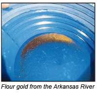 , and they were first worked back in 1859. The town requires a permit even for basic panning at Fairplay Beach, which needs to be validated by the clerk at the town office on Front Street, though it can also be handled through the mail. The permit form is available on the Fairplay town website. (Go to fairplayco.us and click on Forms & Permits, or call (719) 836-2622.)
Arkansas River Area
An extensive area of placer deposits exists for a considerable length along the Arkansas River. For most of this area, the gold in the Arkansas is very fine in size, but there are significant amounts of it. Some nuggets of a little coarser size have been found, but gold nuggets of a gram or larger are few. Much of the headwater area of the Arkansas River as it comes down out of the Leadville area is a designated recreation area. The recreation area is managed by the Colorado State Parks system, and gold panning and small-scale prospecting are allowed. The BLM does require a 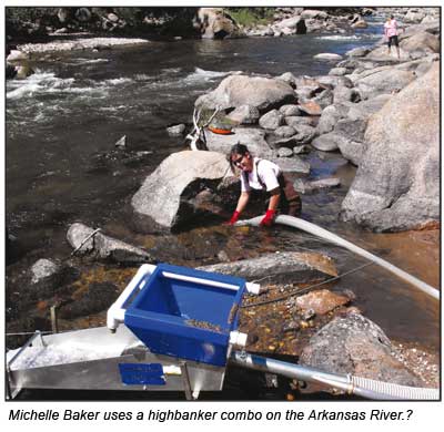 $25 permit for dredging here but the permits are generally not difficult to obtain. Use of suction dredging equipment in the river is limited to intake nozzles no larger than 4 inches and power systems no larger than 8 hp motors. (Google search: BLM dredge permit Arkansas River Colorado.)
There is a patchwork of BLM land, parkland and private property here, and some investigation is needed to see what areas are open to work. The GPAA has a number of claims on the Arkansas River. The Gold Prospectors of Colorado club also has several claims in the Buena Vista/Salida area. There are a number of nice campgrounds and good facilities for the visitor who wants to try his hand prospecting.
Cache Creek
The Cache Creek placer area is located west of the town of Granite in northern Chaffee County. The BLM has also set aside a large parcel for small-scale mining and prospecting at Cache Creek. About 25 acres of a BLM wildlife habitat and wetlands has been opened to prospecting use. Some 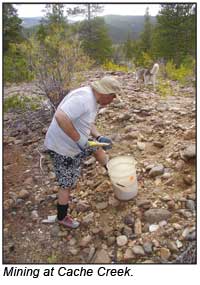 coarser gold nuggets have been found at Cache Creek. The BLM has established certain restrictions and does require a special permit, but like the Arkansas River dredge permits, it is not difficult to obtain. Much of the designated prospecting area requires access by foot. (Google search: BLM dredge permit Cache Creek Colorado.)
Current Commercial Mining
As far as active commercial gold mining in Colorado, the Cripple Creek and Victor open pit mine located in the Cripple Creek District of Teller County is currently the only active large-scale gold mining operation in Colorado. Several hundred employees working for Anglo Gold mine thousands of tons of lower grade ores that are processed by low cost heap leaching techniques.
Although the ores that are being mined contain only a few hundredths of an ounce per ton, the large quantities of material handled make for a significant production, and the mine is the largest employer in its county. Several small underground operations also are working in the Front Range gold belt, including one operated by Global Minerals.
A number of sand and gravel operations along the Platte River and in some other locations in the state also produce small amounts of byproduct placer gold from the processing of aggregate materials.
_______________
Sources
A. H. Koschmann and M. H. Bergendahl, 1968, Principal Gold-Producing Districts of the United States: U.S. Geol. Survey Professional Paper 610, 283 p.
Frank Hall, 1895, The History of the State of Colorado 1868 to 1895, The Blakely Printing Company, Rocky Mountain Historical Society. Four Volumes.
© ICMJ's Prospecting and Mining Journal, CMJ Inc.