All Articles
Free
The Last Chance Mining District
August 2009 by Don
I can tell you now this article covers about ten sections of land, and our exploratory team has covered a lot of it. It doesn’t sound like much until you drop down 1,600 feet into a canyon twice to check out more of the territory. This is very steep country. Without the trails it would be almost impossible to navigate. So what’s this all about? You know the answer—gold! We did find gold, and we need to go back there, but that’s getting way ahead of the story.
Devil’s Basin is on one side of this steep canyon and the Last Chance Mining District is on the opposite side. Between them flows the North Fork of the Middle Fork of the American River, which has cut its way down over 1,600 feet between the two. This area is above the old sites of Damascus and Westville, heading towards the old townsite of Deadwood, now long gone. Even the names make you wonder about the territory.
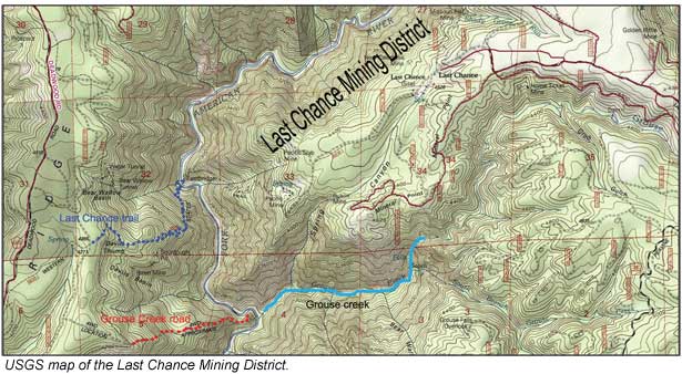
The history of this area goes a long way back. The Last Chance Mining District got its start in 1852, when gold was first found on the North Fork of the Middle Fork, and subsequently in the creeks that flowed down from there, and then to the old buried river channels that were partially eroded out on the mountainside. During the Eocene geologic time, prior to the North Fork of the Middle Fork cutting its way down, a large quartz-bouldered channel ran through the Last Chance area, and then on towards Michigan Bluff near Foresthill. Some geologists and mining engineers consider this flow to be the South Fork of the rich channel that came down from the Hidden Treasure Mine, which was worked for over 50 years.
The Eocene channel was over 400 feet wide in places, but then was completely buried by volcanics. Subsequent erosion patterns brought in a parallel intervolcanic channel that cut its way deeper and deeper, finally cutting over the top and through the Eocene channel, and then going even deeper by 60 to 80 feet. This was like one river cutting deeper through another, with the gravels being of entirely different rock structures, but much more narrow in width.
This more narrow flow was named the Eldorado Channel. It was steeper and therefore flowed faster than the earlier Eocene channel. There were several erosion periods here, leaving higher benches of the Eldorado Channel.
This wasn’t the end of the story though. Another period of volcanics occurred, again burying all of this and an entirely new northeast to southwest erosion pattern occurred, starting at the North Fork of the Middle Fork of the American. This new erosion pattern crosscut these old river flows and exposed the Eocene flow and the channel called the Eldorado on the mountainside.
The USGS map shows the present terrain. Actually, the old river flows are on both sides of the newly cut canyon, and on the Devil’s Basin side is the Sourdough Pit and the channel going into the mountainside there.
All this cutting activity of this modern new river flow (last few million years) put some great gold in the stream, which led to the old channel discoveries.
First the Last Chance mining area. There are two reports on how the name came about. I especially like one of them.
In the early prospecting years, in this deep, remote canyon, two miners were trying to make a go of it. Conditions were tough and a town source many days away. They were out of supplies and were down to one single rifle bullet between them. They were almost starving. They resorted to nothing but hunting and spotted a deer a ways off. They decided which one would fire the rifle, and the other watched his partner and is reported to have said, “Last chance. This is our last chance.” The rifle roared, the deer was down and they had enough food to continue their prospecting. They named the area “Last Chance” and it became history. It’s a good story and well may be true.
With gold being found in the springs and creeks coming down from the mountain, further exploring took place and the Eldorado channel was named, along with a series of mines along the way. Some of these mines were the Pacific Slab, Missouri Flat, Eldorado, Sharp Stick, Little Hope, Star Town, The Root Hog, Golden Riffle, Home Ticket, and others. Most of these mines were drifts, with a few open pits on the mountainsides. All of these mines were going for the Eocene and subsequent intervolcanic flows, and they all seemed to be carrying gold that could be mined at a profit.
Meanwhile, across the canyon in the Devil’s Basin area, more mining was underway, but that history is hard to come by. There are a few references to mining activity here, and the small, one paragraph reports indicate the same basic river pattern as the Last Chance District, with the intervolcanic channel cutting deeper than the Eocene Channel.
I know two very good detectorists who have detected in this very remote and hard to find area, and they were successful in finding some very nice nuggets. Before you decide to fire up your Jeep, you better read the rest of the story, because the fun has only begun.
All of the territory of the Last Chance Mining District is under valid mining claims. I’ve been in many of the tunnels in years past, and the workings have been extensive. I understand there is still plenty of channel left to be worked.
With all of the erosion patterns wearing away the channels down into the North Fork of the Middle Fork, we assumed placer gold was still available in the river. The question became: How do we get down the 1,600-foot elevation drop to reach the river?
The old miners already figured this one out and made a trail from Michigan Bluff; down through Eldorado Canyon (different than the Eldorado Mine); up to Deadwood; across the ridge; plunged down Devil’s Basin past Devil’s Thumb; hit the North Fork of the Middle Fork, and then back up the mountain to the Last Chance Mining District. It’s a long, 3-day hike.
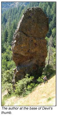
The modern Western States Trail also decided to follow this route, and today the 100 mile Western States Endurance Run uses this part of the trail, as does the Trevis Cup, which is the endurance horse-riding event. It sounded relatively easy, except the trail that drops off from Devil’s Thumb to the river is at a very steep angle and gets worse as it gets to the bottom. Well, this was our choice. But Devil’s Thumb? What was that?
At the top of the mountain, just at the point of starting down, was the answer. Keep in mind the top of this entire ridge is an andesite volcanic flow, heavily cemented, with lots of volcanic boulders encrusted. The flow is several hundred feet deep. Here’s what we saw—a tower-like rock structure, maybe forty feet in diameter, going up for a distance of maybe 80 to 90 feet. From one angle, it looks like a giant thumb coming up from the ground, and maybe that’s appropriate for the Devil’s Basin! When we first saw it we thought is was solid rock, but instead its cemented andesite that has been eroded all the way around it. It’s startling.
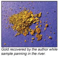
Down the trail we went, and, although steep in places, the trail was excellent. Towards the last 300 feet of elevation change it pitched hard, with about 20 switchbacks to reach the bottom. Mosquitoes were everywhere and coming back was worse. You didn’t dare to stop long because they were after you. At the bottom was the river, a beautiful flow, with bedrock showing, and the old bridge used to cross the river was still there, in excellent condition. We crossed, and decided to head downstream on the opposite bank. The river was not that high, with this being late June (2009). Some places were too swift to cross back and forth. It generally averaged about two feet deep, and boulder hopping, with some wading, could get you across at some places. We sampled here and there. Then we started finding some gold, fine at first but a little heavier the more we worked the bedrock area.
Time flew though and the hike out was going to be a tough one for sure. The drop down had been about 1,600 feet or so, but very steep. We reluctantly decided to head back, not sure how long it would take, but at least 1½ times as long as it took coming down. Maybe it would take twice as long. The gold panning was getting better, but the time frame started to be a concern. We had only prospected a few hundred yards so the sampling was very limited, but very promising.
Time to go back up the mountain. It was a tough pull but the promise of more gold later to come was encouraging. We reached the top with plenty of daylight left and now the planning started for another trip down. We needed to explore it much more before reaching any conclusion about more serious prospecting.
A few days later we were at it again. The map had revealed another trail down called the Grouse Creek Trail, just about one-half mile away, ending downstream from the bridge of the Last Chance Trail. Some earlier exploring had located a four-wheel-drive road dropping off the mountain there and it appeared to be the way down, since the actual trail on the USGS map wasn’t evident. There was only one way to find out and that was to hike down it. I had driven down the dirt road a short distance earlier, but it had a really bad turn in the andesite and my four-wheel-drive Geo did not like the looks of coming back up that loose, pebbled, steep, sharp, rutted turn.
The road appeared to follow the Grouse Creek Trail that was shown on the map and most likely the map was out-of-date, which is not unusual for USGS maps. Grouse Creek was actually coming down the other side of the mountain, from the Last Chance Mining District. That made the creek promising because it likely cut some of the old channel. Based on this, we wanted to be on the river below where the creek came in. The map also showed a complete horseshoe bend in the river at the creek area, and this was even more promising.
The four-wheel-drive road was really good in spots and rough in other places, with protruding rocks just waiting for a vehicle with a low profile to come along. The road continued down though, and was cut in the mountainside. The bedrock from the road cut was up 15 feet on one side and down to almost zero on the other. This mountain was running 45 degrees downward, and without the road, the trip down would not have been possible.
Then the road went down sharp, and we could hear the sounds of the river. In 10 minutes we were there, on a flat with the river not more that 20 yards away! It was a very flat area with an old winch still sitting there from perhaps the 1930s. It was huge, with a one-inch cable. It had two drums and probably weighed 15 tons. (No wonder it was still there.) They must have used it to move large boulders from the horseshoe bar area on the river.
There were a couple of mining claim signs up that had a place on them for the claim name and the California Mining Claim (CAMC) number. Nothing was filled out. It is very important for claim holders to provide this information, especially the CAMC number. It didn’t appear that anyone had been there for a long time. I’m aware that the area just upstream was filed on by a friend, and it was my understanding all this was open. (Note: It was discovered later that the area discussed is under claim by the Comstock Gold Prospectors, a club based in Reno, Nevada. The author offers his sincere apologies for this error. If you would like access to mine in this area, you can get information on joining the Comstock Gold Prospectors by visiting www.cgpgold.org.)
.jpg)
We crossed the river and headed downstream, looking for Grouse Creek to come in. The horseshoe bar area of the river was a long, sweeping turn, taking maybe a good 200 yards to complete the total bend. Bedrock was hit and miss, but promising.
Finally we reached Grouse Creek coming in and we started panning. At first nothing, but we were in a very swift area of the river when it had been booming. As we backed up in the horseshoe area along the river the gold started coming in. As usual, we spent a lot of time exploring the river and we therefore cut down on our panning time. That’s necessary though. A prospector can’t expect to be getting gold right off. You should explore an area first, seeing what’s available and where the best area is to begin.
Prospecting can take many days when evaluating an area, and some areas may take even longer. This was going to take a lot more looking than just one day. With nice color being found, it was time to go, knowing that we had accomplished our objective of first just getting there! Sometimes that doesn’t even happen.
The road back up was torturous, because the grade never seemed to cease, and the mosquitoes swarmed when you stopped. Maybe in another month the mosquitoes will be gone and a prospecting trip back to the area will be more comfortable.
© ICMJ's Prospecting and Mining Journal, CMJ Inc.